


- 2:50 h
- 8.63 km
- 370 m
- 470 m
- 565 m
- 795 m
- 230 m
- Start: Giessbach watherfalls
- Destination: Iseltwald
In summer, the lakeside path extending from Iseltwald to Giessbach attracts hordes of ramblers and hikers. While it overshadows the forest path higher up on the slope, the latter route also promises to lead hikers to some spectacular landscapes. The path can be done with an outdoor approved pram.
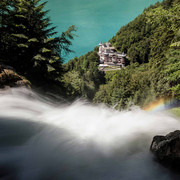
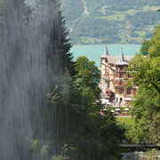
The starting point is the Grandhotel Giessbach, an enchanted castle occupying a fairytale location by Lake Brienz. The palatial hotel takes its name from the Giessbach, which flows thunderously into a majestic waterfall a stone’s throw away.

Good to know
Best to visit
Directions
You start at the Giessbach waterfalls and with no altitude differences to speak of, a wide gravel path leads through the forest to the Unterholz fork and on to two agricultural clearings (Kusterboden and Hohflue) before re-entering the forest. At the next junction on the path, matter-of-factly signposted «700 m», there are two hiking routes to choose from, both heading towards Iseltwald. The shorter option slopes gently down to another branch after a few hundred metres, where the Farnihubel is also signposted.
A narrow path winds through an increasingly wild and rocky landscape. Passing rock faces – some of which are vertical, some of which overhang – you enter a mesmerising world. Various species of fern grow between the trees, which partly explains the name of the region. Although the terrain is distinctly rugged, hikers are in no danger as long as they stay on the path. There are two benches at the very end of the path where hikers can drink in the views as far as Iseltwald and Schnäggeninseli island.
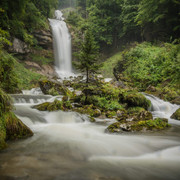
You leave the maze-like Farnihubel by the same route you came. After this, you come to the only climb worthy of the name on the tour, which leads up from the aforementioned «700 m» fork in the direction of Isch. Thereafter much of the walk is over open terrain, guiding hikers through a patchwork of beautifully maintained, cultivated landscapes – one of which is the Louberli farm. The final gem on the route is the Mülibach waterfall, where the waters gush into a round pool from a vertical rock face. After the waterfall, you descend through the forest to the motorway and reach the village of Iseltwald.
Directions & Parking facilities
Anreise: Mit Schiff und Standseilbahn nach Giessbach/Hotel
Rückreise: Ab Iseltwald mit dem Schiff oder mit dem Postauto
Additional information
The Louberli – the farm in clinging to the steep slope – is home to goats, woolly pigs, peacocks and other livestock; herbs, spices and many fruit varieties are also grown. Thanks to its biodiversity, the area was awarded the Cultivated Landscape Prize for the East Oberland region in 2016.
Every year, the «Cultivated Landscape Prize» is awarded to the most beautiful, and most valuable, areas of cultivated landscape in the East Oberland region. By supporting and boosting the area’s image through tourism, the award incentivises farmers to manage their land sustainably and help preserve our beautiful natural environment.
Looking for more hiking choices?
Here you will find details of hiking trails to inspire you in the Bernese Oberland.
Author´s Tip / Recommendation of the author
For an introduction to the hike, visitors are advised to join the circular route which extends from the Grandhotel Giessbach and traces the stream as far as the waterfall before coming back down the other side. A footbridge enables walkers to traverse the slope behind the thundering volume of water.
Nearby


