- 3:25 h
- 9.88 km
- 307 m
- 1,098 m
- 1,223 m
- 2,316 m
- 1,093 m
- Start: Kleine Scheidegg, Wengernalp railway end station
- Destination: Bahnhof Wengen, Station der Wengernalpbahn
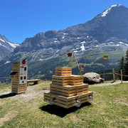
The Lauberhorn Ski Race is the longest and most demanding downhill event in the Ski World Cup. In summer you can actually experience the key points on the racing piste. The Lauberhorn Trail leads to spectacular passages including the Hundschopf and Wasserstation. Twelve information panels along the trail give interesting facts on the route of the race. The route is also lined with photo-viewers, similar to telescopes aimed at mountain summits, which show the exact route of the race. Start at Kleine Scheidegg: At Kleine Scheidegg railway station you cross the railway tracks and head towards Männlichen. After a few steps you branch off to the left on the mountain trail to Lauberhorn for a gentle but steady climb. At the top station of the Wengernalp/Wixi-Lauberhorn chairlift (open in winter), is a signpost for the Lauberhornschulter (shoulder) and the start of the Lauberhorn Trail. At first this narrow downhill path over mountain pastures more or less follows the route of the Wixi chairlift before bending to the west after 300 metres. In front of you is a small man-made lake which supplies water to make artificial snow for the pistes in late autumn. Key points in the summer: The Lauberhorn Trail leads steadily downhill via Rinderhitta. The narrow bottle-neck at the Hundschopf is mastered in several bends. Just below Wengernalp railway station, you reach the tracks of the Wengernalp Railway and follow these in the direction of Wengen. At the benches above Wasserstation - where steam trains once topped up their boilers - the trail turns to the left, crosses under the railway tracks and continues via Wickibort to Hannegg, where it leaves the actual race piste. You then hike gently downhill through peaceful mountain forest on the Wengen-Wengernalp alp road to Allmend, a station of the Wengernalp Railway.
Good to know
Best to visit
Directions
Equipment
Directions & Parking facilities
In Grindelwald there are two public car parks with covered spaces to choose from: Eiger+ multi-storey car park (252 spaces) and Sportzentrum multi-storey car park (160 spaces). Uncovered parking spaces are available throughout the village.
Lauterbrunnen
Lauterbrunnen multi-storey car park directly at the railway station or the uncovered car park by the church.
Additional information
(in the printed summer panoramic map of the Jungfrau Railways)
Safety guidelines
Nearby


